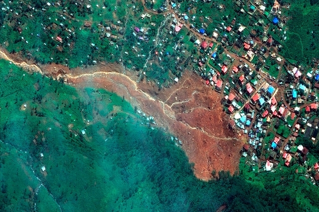
FREETOWN'S FLOODINGS : Natural or political hazard?
"For
forty days the flood kept coming on the earth, and as the waters
increased they lifted the ark high above the earth. 18 The
waters rose and increased greatly on the earth, and the ark floated
on the surface of the water. 19 They
rose greatly on the earth, and all the high mountains under the
entire heavens were covered. 20 The
waters rose and covered the mountains to a depth of more than fifteen
cubits.[a][b] 21 Every
living thing that moved on land perished—birds, livestock, wild
animals, all the creatures that swarm over the earth, and all
mankind. 22 Everything
on dry land that had the breath of life in its nostrils died."
A long time ago, humans were afraid about rainfall. It has been for a
long time an significant natural threat for humans, and many myths
and legends are based on disasters caused by water flows.
In Freetown, it continues to be a nightmare.
Freetown
Case Study:
Facts:
Freetown
is the capital of Sierra Leone, on the west coast of the African
Continent. Its popuation is around 1.2 million (Siences
et Avenir) and is increasing very rapidly.
On
the 14th
August 2017, Freetown was beset by three days of torrential
rains resulting in mud flows entering the streets of the city and swathes of hills
collapsing on the residential areas (Siences
et Avenir).
Consequences:
The
damage was tremendous. On the 21st
of August, it was reported that 500 people died in this dramactic event (Afrique
Asie)
and 800 were yet to be found (LaCroix
).
In addition to the death toll, material deterioration was also very
significant and caused widespread inconvenience.
Amnesty
Internationale estimated the number of dwellings to have been destroyed to be more
than 3 000. Unfortunately, dwellings were not the only material
affected, health facilities were also severely affected.
An overview of what living in Freetown looks like during floodings
Source: A. Sumbai et al. 2017 UCL
Ironically, the consequences of these floodings can dramatically affect water supplies in a city. For instance, water supplies became unusable, and wells contamined, with the water becoming no longer drinkable (Afrique Asie) -inducing water scarcity and need for aid from external organisations.
Moreover,
the threat of disease outbreak has increased. This is mainly due to uncontrolled water flows and ill-treated dead bodies, which are very important factors of diseases' expansion.
As
we can see consequences spurred on other more severe consequences. But, why did these natural hazards happen in Freetown?
Causes:
Climate
change:
Sierra
Leone floodings are the consequences of high density of rainfall during the rainfall season
(Siences
et Avenir). As I explained about the new characteristics of climate in
West Africa
principally, rain seasons are now shorter, dotted with extreme pluviometric events. The three days of intense rainfalls illustrate this phenomenon very well.
History
and Geography:
Moreover,
this capital is one of the several African post-colonial cities, that
have been urbanised mainly during the XVIII and XIX centuries. As we
can see on this map, it has been urbanised on the coast and expanded only to the West and East (J.Rossano,
1969 ).
Freetown city
Source: J.Rossano, 1969
The
map also shows that the relief plays an important role in this. The
contour line indicates that the altitude increases towards the South (180m). So actually, the relief of this area is already favourable to
floodings, mud flows and land collapses.
Lack of urban planning:
Therefore, dwellings on this
part have been established after the principal urbanisation of
Freetown which according to
Siences
et Avenir has never had any urban planning for this part of the city and
that's a quite significant problem for a city that has its population
growing by 123.6% over three decades (1985-2015) (L.R. Mansaray,
2016) !
Source : AKODY
So
in addition to a geographical condition which favours floods and
its consequences, the gaps in housing and environmental policies
demonstrated in this city enhance this phenomenon and the damage that it induces.
Freetown,
its relief and its crammed population
Source :
La
Ballade de Pégase
Deforestation:
BUT, as if that was not enough we must also mention the implication of
deforestation in this region, that considerably interact with changes
of characteristics of climate.
These three last decades have witnessed Freetown's land-cover to have dramatically changed in
the same way as all the country (L.R. Mansaray,
2016). Population growth and post war economic recovery are the largest factors of this transformation (L.R. Mansaray,
2016).
This Landsat datas is definitely relevant to the understanding the changes of land-cover and the significant environmental transformations of
this region.
Land-cover
map of Freetown at 1986
Source :
L.R. Mansaray,
2016
Land-cover
map of Freetown at 2001
Source :
L.R. Mansaray,
2016
Land-cover
map of Freetown at 2015
Source :
L.R. Mansaray,
2016
According
to these images, I think this is relevant to assert that these dense forests
have been mainly replaced by built-up areas, particularly in the
North-West and the South-West of the Peninsula and large spaces,
especially between forest and housing areas, are now open.
Could
you remember what I've said about the effects of the decline of
land-cover on water filtration? The decline of vegetation
because of droughts has generated in many countries in West Africa an
augmentation of run-off rates.
I
think Freetown's floodings can illustrate quite well this
correlation. This area, already vulnerable to floodings issues, has
increased its own vulnerability by deforestation activities.
The changes of climate characteristics, the geography and also the housing and environmental policies enhance the consequences of floodings in Freetown, and this makes me definitely confused in understanding how this hazard could not be anticipated and managed.


Commentaires
Enregistrer un commentaire